
Mynd:2022 Russian invasion of Ukraine.svg

Upphafleg skrá (SVG-skrá, að nafni til 2.199 × 1.478 mynddílar, skráarstærð: 3,72 MB)
Rules for editing the map
|
| All edit warring, adding of unsourced information or performing a color change without consensus may result in the user being blocked. All contributions should first be discussed on the talk page. |
Lýsing

|
This file may be updated to reflect new information. If you wish to use a specific version of the file without new updates being mirrored, please upload the required version as a separate file. |
| Lýsing |
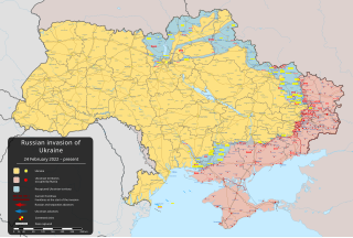
English: Innrás Rússa í Úkraínu 2022 – vopnuð átök sem hófust 24. febrúar 2022 þegar rússneski herinn fór inn í Úkraínu [] |
||
| Dagsetning | 24. febrúar 2022 (first version) | ||
| Uppruni |
Own work based on: Russo-Ukrainian conflict (2014-2022).svg by Rr016 & Ukraine adm location map improved.svg by Yakiv Gluck
|
||
| Höfundarréttarhafi | Viewsridge | ||
| Aðrar útgáfur |
[]
|
||
| SVG genesis | This map is translated using SVG switch elements: all translations are stored in the same file.
|


.gif)

.gif)


_en.png)
_vi.png)
_ru.png)
.svg)
This file is translated using SVG <switch> elements. All translations are stored in the same file! Learn more.
For most Wikipedia projects, you can embed the file normally (without a To translate the text into your language, you can use the SVG Translate tool. Alternatively, you can download the file to your computer, add your translations using whatever software you're familiar with, and re-upload it with the same name. You will find help in Graphics Lab if you're not sure how to do this. |
Leyfisupplýsingar:
- Þér er frjálst:
- að deila – að afrita, deila og yfirfæra verkið
- að blanda – að breyta verkinu
- Undir eftirfarandi skilmálum:
- tilvísun höfundarréttar – Þú verður að tilgreina viðurkenningu á höfundarréttindum, gefa upp tengil á notkunarleyfið og gefa til kynna ef breytingar hafa verið gerðar. Þú getur gert þetta á einhvern ásættanlegan máta, en ekki á nokkurn þann hátt sem bendi til þess að leyfisveitandinn styðji þig eða notkun þína á verkinu.
- Deila eins – Ef þú breytir, yfirfærir eða byggir á þessu efni, þá mátt þú eingöngu dreifa því verki með sama eða svipuðu leyfi og upprunalega verkið er með.
Breytingaskrá skjals
Smelltu á dagsetningu eða tímasetningu til að sjá hvernig hún leit þá út.
| Dagsetning/Tími | Smámynd | Víddir | Notandi | Athugasemd | |
|---|---|---|---|---|---|
| núverandi | 13. maí 2024 kl. 05:36 | | 2.199 × 1.478 (3,72 MB) | Alexiscoutinho | Updated Vovchansk per detailed map |
| 13. maí 2024 kl. 02:49 |  | 2.199 × 1.478 (3,72 MB) | Physeters | Updates per the ISW; for future reference, sources (like SuriyakMaps) must first have their reliability vetted on the talk page before they can be used to update the map; at the moment, the only two verified sources are the ISW and the Detailed Map on Wikipedia | |
| 12. maí 2024 kl. 10:34 |  | 2.199 × 1.478 (3,31 MB) | BlackShadowG | File uploaded using svgtranslate tool (https://svgtranslate.toolforge.org/). Added translation for zh-tw. | |
| 12. maí 2024 kl. 08:46 |  | 2.199 × 1.478 (3,31 MB) | Miki1234568 | File uploaded using svgtranslate tool (https://svgtranslate.toolforge.org/). Added translation for pl. | |
| 12. maí 2024 kl. 07:54 |  | 2.199 × 1.478 (3,31 MB) | BlackShadowG | File uploaded using svgtranslate tool (https://svgtranslate.toolforge.org/). Added translation for zh-cn. | |
| 11. maí 2024 kl. 23:02 |  | 2.199 × 1.478 (3,71 MB) | Mattia332 | As per Renowned Unbiased Open Source "SuriyakMaps", Russian progress in Kharkov | |
| 10. maí 2024 kl. 19:38 |  | 2.199 × 1.478 (3,71 MB) | Physeters | add date marker | |
| 10. maí 2024 kl. 19:31 |  | 2.199 × 1.478 (3,71 MB) | Physeters | Update per the ISW; Russia re-enters northern Kharkiv Oblast | |
| 9. maí 2024 kl. 04:45 |  | 2.199 × 1.478 (3,7 MB) | Physeters | Updates per the ISW; add Ocheretyne | |
| 8. maí 2024 kl. 19:22 |  | 2.199 × 1.478 (3,7 MB) | Alexiscoutinho | Updated Kyslivka per detailed map |
Skráartenglar
Eftirfarandi 2 síður nota þessa skrá:
Altæk notkun skráar
Eftirfarandi wikar nota einnig þessa skrá:
- Notkun á af.wikipedia.org
- Notkun á als.wikipedia.org
- Notkun á am.wikipedia.org
- Notkun á ang.wikipedia.org
- Notkun á an.wikipedia.org
- Notkun á ar.wikipedia.org
- Notkun á ary.wikipedia.org
- Notkun á arz.wikipedia.org
- Notkun á ast.wikipedia.org
- Notkun á azb.wikipedia.org
- Notkun á az.wikipedia.org
- Notkun á bat-smg.wikipedia.org
- Notkun á bcl.wikipedia.org
- Notkun á be-tarask.wikipedia.org
- Notkun á be.wikipedia.org
- Notkun á bg.wikipedia.org
- Notkun á bh.wikipedia.org
- Notkun á bn.wikipedia.org
- Notkun á br.wikipedia.org
- Notkun á bs.wikipedia.org
- Notkun á bxr.wikipedia.org
- Notkun á ca.wikipedia.org
Skoða frekari altæka notkun þessarar skráar.